

An Isle of Skye Road Trip : Part 1 - The Trotternish Loop
In the first of a series of three articles exploring the Isle of Skye by road, we tackle the Trotternish Loop, taking in some of the island's best known attractions

This post can also be read at the Above Us Only Skies website
Along with the North Coast (NC) 500 route, an Isle of Skye road trip is a Scottish rite of passage for many who visit the rainswept Highlands.
The fabled “Misty Isle” is by no means an easy drive, though – mainly due to an explosion in tourist numbers over the past two decades. But, if you look past the craterous potholes, the narrow single-lane tracks, the amateur hour attempts at using passing spaces, the horrible over-crowding and the notoriously fickle weather, we promise you’ll have a blast.
As long as you remember patience is very much your friend.
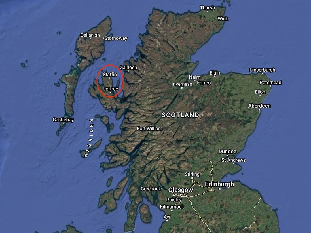
Overall, we spent six weeks house sitting on the island during October and November, when most high-season tourists had gone. Luckily, we had our own car, which meant we could pick our days to venture out when the weather forecast was a positive one (or, in reality, less than abysmal). And, in that time, we explored much of the island, given the limitations of the relatively short late-autumn days and the seasonal closure of many attractions and restaurants.
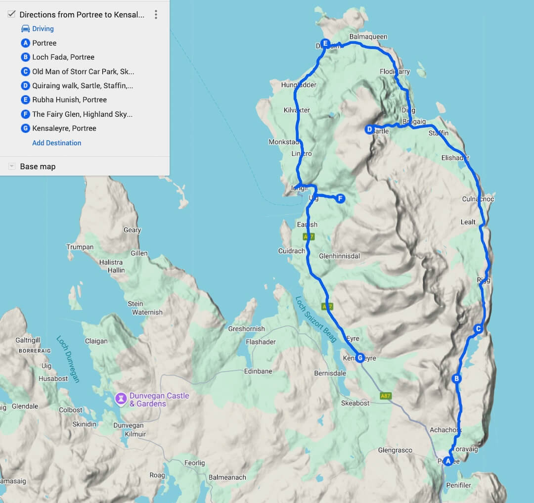
In this first of three articles, we’ve combined our exploits into one continuous road trip. Starting in Portree, Skye’s capital, we follow the road north into the Trotternish Peninsula before heading (in Part Two) to the island’s most westerly tip at Neist Point and (in Part Three) south towards the majestic Cuillin Hills. Along the way, there are some cultural and historically significant sights. But most road-trippers are here because of the jaw-dropping scenery and fabulous walking opportunities. Of which there is so much.
So, without further ado, let’s fasten our imaginary seatbelt, switch on the ignition and take a deep breath as we head off on an Isle of Skye road trip for the ages.
Disclosure: This page contains affiliate links, which means that if you ultimately make a purchase, we earn a small commission at no extra cost to you. And it helps to keep our content free!
Portree
If you’re spending any time on Skye, chances are you’ll be sleeping at least one night in Portree. After all, it’s the island’s capital and has the most variety of hotels, B&Bs and restaurants. Although it’s full to the rafters during the uber-busy summer months.
The harbour area is lined with pastel-coloured cottages – a nod to its original status as a simple fishing village. And, for the road tripper, it scores highly for having one of the island’s few petrol stations. Not to mention a decent supermarket for those last-minute essentials.
But, for our road trip, it serves as a convenient starting point for the Trotternish Peninsula.

Loch Fada
The A855 out of Portree is a gentle introduction to some of the more challenging terrain ahead. The road climbs slowly away from the town until it morphs into a snaking single-track road with passing places.
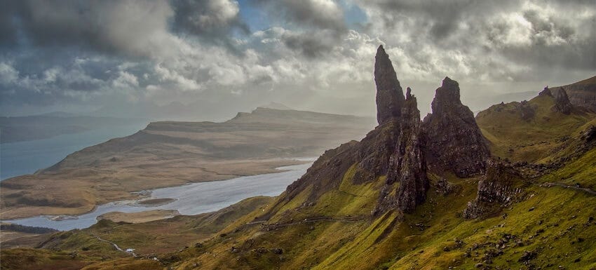
Five minutes in and the iconic Skye image of The Old Man of Storr makes its first appearance away in the distance. It’s a 55-metre pinnacle standing proud at the end of a section of the Trotternish Ridge. And, before it, the calm waters of Loch Fada, with its tiny island as a focal point.
As the road begins to descend on the loch we pull over to the right where a small clearing provides enough room for perhaps two cars to park. The view from there is an Instagram favourite for a reason. And, even though the weather is heavily overcast, shafts of sunlight break from the clouds and dance around the ridge.

The Old Man Of Storr
Hungry for more, we return to our car and head onwards as the road widens and hugs the loch, passing Bride’s Veil Falls on our left.
Also to our left, the imposing Trotternish Ridge (which runs almost the entire peninsula) is upon us. Created by a base layer of clay giving way under the weight of 60 million-year-old volcanic rock, the ridge is what remains after the huge landslip that followed. Meanwhile, Skye’s infamous weather has gone to work carving pinnacles and other bizarre rock formations like some celestial sculptor.
The Old Man himself is without doubt Skye’s most famous pinnacle. From the official car park (£6 fee in 2024) on the A855, it’s a two-hour round trip walk to the viewing point. A good proportion of it is steep. And the outbursts of rain, combined with the gusts of wind, make the going a little tough. But the payoff is a fabulous view of the Old Man against a background of the Storr Lochs and the islands of South Rona and Raasay beyond.
MORE ON THE OLD MAN OF STORR HIKE
Distance: 3.5 km Time: 2 hours Car Park: £6 (Nov 2024) Type: There and back Difficulty: Moderate Terrain: Gravel path, steep in parts

Suitably awed by the Old Man’s otherworldliness, we continue north along the A855 for three miles, before pulling off at the Tobhta Uachdrach viewpoint. Once home to a thriving community, the area’s residents were forced from their land to make way for sheep farming, many of whom emigrated during the early 19th century to North and South Carolina, USA and Canada. Nowadays it serves as an elevated viewpoint of the coastline, mainland Scotland and an alternative view of the Old Man of Storr.
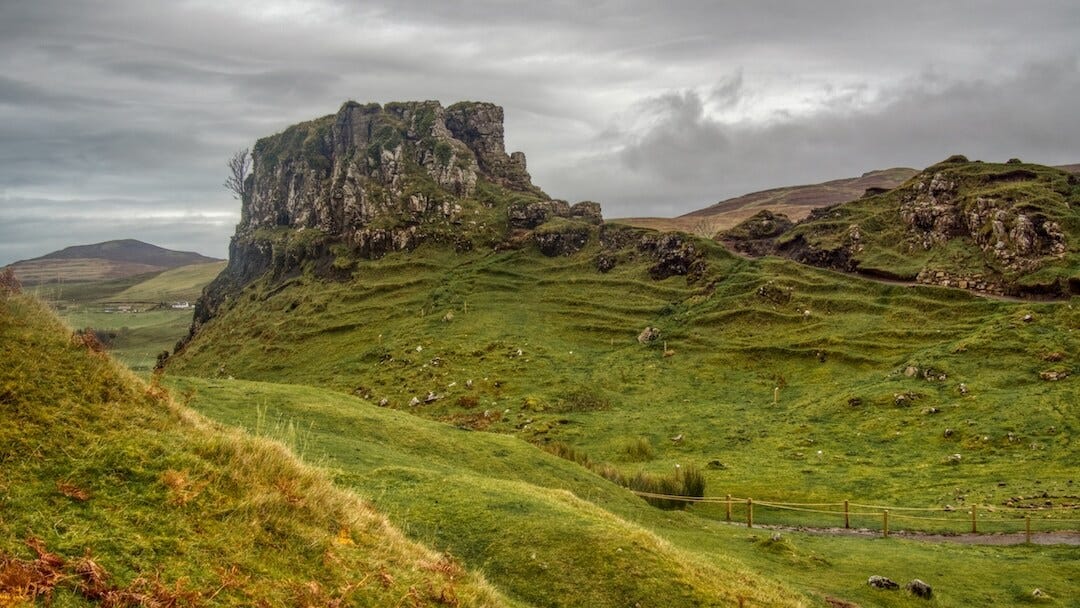
Next, we skip the opportunity to walk to Lealth Falls by heading towards Staffin. A large car park on our right announces we’ve arrived at the cleverly-monikered Kilt Rock, which – as you’ve surely worked out – is a series of cliffs featuring enormous, hexagonal columns of basalt resembling a tartan kilt. Pride of place, though, is the stunning waterfall tumbling from the cliff face to the rocky beach some 60 metres below.
A couple of miles beyond, Staffin is a good option for an overnight stay. Featuring the whitewashed, grey-roofed croft cottages so typical of Skye, it’s an obvious place to stop for easy access to The Quiraing and the Trotternish Ridge. And there’s the added bonus of discovering dino footprints on nearby An Corran Beach.
HAVE YOU CONSIDERED HOUSE SITTING?
Over the years we've saved thousands of pounds on accommodation costs by house sitting all over the world. If you’re new to the concept but want to give it a try, you’ll need to sign up for one or more specialist websites that connect homeowners with potential house sitters.
The world’s largest platform is Trusted Housesitters, with tens of thousands of opportunities around the globe. By creating a free account with them you can preview what housesits are currently on offer, filtered by country, region or city. You can do that by following this link and choosing the “Find a house sit” tab. If you then decide to join as a member, you’ll also receive a 25% discount on your first year’s subscription.
Everything You Need To Know About House & Pet Sitting
The Quiraing
We carry on through Staffin and take a left (signposted “The Quiraing”). The largely single-track road is increasingly narrow, steep and twisting, with passing spaces alternating on each side. Suffice to say, it brings us into contact for the first time with Skye’s legion of less-than-competent tourist drivers.
Road etiquette in these parts dictates that if you’re in a better position to pull into a passing space than the driver ahead, pull over to the space on your left. Or stop adjacent to the space on the right and let the oncoming driver slip into it as you pass. For Brits and anybody else who normally drives on the left, that’s pretty obvious.
Not so for those visitors whose countries insist on driving to the right. Indeed, it only takes one bright spark who believes “right is right” to massacre the procession of cars, camper vans and tour buses. And so it is on the route up to the Quiraing.
After much arm waving, head shaking and righteous indignation, we finally make it to the car park on the brow of the ridge. Our entrance is temporarily delayed by three kilted gentlemen in their finest, posing for photographs with a small group of excited teenagers.
From the car park, we have two choices. Take the steep hiker-free path to our right along the edge of the ridge to Bioda Buidhe, or follow the tourist trail on our left to the Quiraing viewpoint. Opting for the latter, we find ourselves at the viewpoint within five minutes. In front of us, a flattish path follows the foot of the ridge until it dissects two spires in the distance. To our left, a series of stone steps zig-zag their way up the escarpment. And, in between, the precipitous Trotternish Ridge connects the two.
The Quiraing itself is partially hidden from view. A collection of pinnacles and bizarre rock formations, it’s best known for its three most notable features – The Needle (a 37-metre-high standalone pinnacle), The Prison (a fortress-like rocky outcrop) and The Table (a hidden plateau in an ampitheatre high up on the ridge). Back in the day, farmers hid their cattle and sheep within the confines of the Table from marauding Vikings. And even played football games up there. A film plot that, mercifully, Mel Gibson seems to have overlooked after his fact-free rampage through the William Wallace story in Braveheart.
MORE ON THE QUIRAING HIKE
Distance: 6.8 km Time: 2.5 hours Car Park: £3 for 3 hours; £5 for 6 hours (Nov 2024) Type: Loop Difficulty: Moderate Terrain: Gravel and rocky path, boggy section on ridge, steep in parts
READ MORE: The Isle Of Skye Quiraing Walk

Bioda Buidhe
Rather than return to our car, we skip over the Staffin-Uig road and head up the loose footpath along the edge of the opposite ridge. It’s a steep climb but comes with ever-increasing panoramic views of the Quiraing as the Needle and Prison rock formations fade into the distance.
Peering over the edge, we see the twin lochs of Leum nu Luirginn and Cleat rippling in the wind. And, as we continue upwards, sheer drops look down on dramatic rocky outcrops surrounded by a sea of green.
In stark contrast to the Quiraing hike, we have the place to ourselves. One of the advantages of such a breathtaking trail lurking in the shadow of one of Skye’s must-do attractions.
The summit at Bioda Buide is a further 20-minute climb that’s steeper again. But the views through a gulley and beyond the twin lochs toward the Quiraing are sensational. And, to our right, the Trotternish Ridge carves its way south beyond the now-familiar sight of the Old Man of Storr.
If anything, this is the best view of the Quiraing. But any hopes of lingering for a while are dashed as Skye’s fickle weather delivers an approaching cloud of mist and rain. Figuring that an edge-of-the-ridge descent in those conditions would be pushing our luck, we head back on a more direct, but boggy route to the safety of our car.
MORE ON THE BIODA BUIDHE HIKE
Distance: 2 km Time: 1 hour Car Park: £6 (Nov 2024) Type: There and back Difficulty: Moderate Terrain: Moorland path, not well-marked, steep

Rubha Hunish & The North Coast
Returning to the A855, the road continues to hug the east coast as it passes the village of Flodigarry before curving westwards around the northern extremity of the ridge. It feels like we’ve arrived at the end of the world, where the only signs of life are the croft houses, fields of sheep and the occasional brightly-coloured Highland Cow.

At the 24-mile mark north of Portree, the lush green landscape, dotted with neutral white and grey croft houses, is abruptly interrupted by the appearance of a shocking red phone box. Quite what it’s doing on the corner of a junction in the middle of nowhere is anybody’s guess. But it does serve as the starting point for the Skye Trail, a seriously challenging hike that runs the length of the island.
We take a right at the phone box and park at the entrance for the trail to Rubha Hunish, Skye’s most northerly point. The size of the car park (it’s tiny) provides a clue as to how many other hikers we’ll bump into today.
The easy trail snakes through moorland, overlooking a narrow offshore island and the ruins of Duntulm Castle to our left. 30 minutes later we arrive at a small, white square building perched near the cliff edge. Back in the day, it was used as a coastguard lookout – and, at first glance, it looks like it’ll mark the end of the trail.
But, peering over the edge, we look down on the peninsula of Rubha Hunish pointing like an index finger from the 100-metre cliffs towards the Outer Hebridean island of Harris, its grassy moorland interspersed with pockets of miniature lochs.
The route down looks impossible from here, but to the left, an access trail traverses the cliffs (it’s not as daunting as it first looks) and leads us down to the headland. We’re greeted by a small group of sheep who bestow upon us a contemptuous stare for having the audacity to interrupt their idyllic grazing.
Ignoring them, we follow the footpath around the perimeter of the headland, losing ourselves in a rugged landscape of gullies, sea stacks and arches, while guillemots, shags and razorbills chatter and compare wing sizes on the rocks below.
After the relative crowds at The Old Man of Storr and the Quiraing, this feels like untouched Skye. The raw beauty of the headland, the crashing surf and the din from the sea birds combine to make its northernmost tip a special place to linger.
MORE ON THE RUBHA HUNISH HIKE
Distance: 7 km Time: 3 hours Car Park: Free (Nov 2024) Type: Loop Difficulty: Easy-moderate Terrain: Moorland path, mostly gentle incline with one steep section


Beyond the lonely red post box, the A855 continues to wind its way along the north coast as the landscape changes once again. To our right are views across to the Outer Hebrides. But, to our left, as we’re now travelling on the opposite side of the Trotternish Ridge, the once ever-present sloping escarpment has disappeared.
We circle a headland overlooking the harbour at Uig, which serves as Skye’s ferry port for the Outer Hebrides. A glance at our map shows we’re close to the Isle of Skye Brewing Company, which raises some excitement for the non-driver in our party. However, excitement turns to crashing disappointment when we arrive at its premises on the harbour, only to find it’s merely a bottle shop rather than the brewery’s tap room.
The Fairy Glen
Just beyond Uig, a sharp left turn from the A87 leads to Balnaknock (translated from Gaelic as Village in the Hills). Better known (or marketed) as The Fairy Glen because of its curious landscape of cone-shaped hillocks and its centrepiece, Castle Ewen, a rocky outcrop resembling a fairie castle.
Of all the sights we’ve seen to date, this one is perhaps the most underwhelming. But the clamber up to the top of the “castle” provides a 360-degree view of the glen, with its distant waterfalls adding a certain mystic charm.
Although the Instagrammable fairy stone circle at the base of the castle is clearly nothing more than a collective piece of “art” cobbled together by over-enthusiastic visitors.
Back on the A87, we continue on the coastal loop back towards Portree. However, we’re not ready to return just yet. On our right, the wonderfully named Loch Snizort Beag separates us from our route to the northwest of the island.
It’s where our housesit accommodation is based.
It’s where castles, white coral beaches and mighty cliff walks rule.
And it’s where the phrase “potholed roads” doesn’t even begin to describe the driving conditions we’re about to encounter.
All in Part Two, coming soon.
MORE ON SKYE & SCOTLAND
10 Fabulous Isle Of Skye Viewpoints
The Magnificent St Abbs Head Coastal Walk