

The Isle Of Skye Quiraing Walk
As one of Scotland’s most iconic hikes, The Quiraing Circuit is also one of the best walks on Skye and shouldn’t be missed by any visitor to the island – no matter the weather

The Isle Of Skye Quiraing walk is one of those tick-the-box experiences that everyone should enjoy on a visit to Scotland’s Misty Isle. And, judging by the crowds that turn up in campervans and tourist buses, that’s exactly what most visitors do.
The full Quiraing circuit has its tougher sections. But any mobile person can at least experience enough of the amazing landscape to come away with a smile the size of Scotland.
Of course, this being western Scotland, how much of the landscape you can expect to see is in the lap of the weather gods. We were lucky enough to be able to spend most of October and November on the island, so we could pick our moments when the biting wind and rain had gone. But, even then, the weather changed dramatically over the course of a few hours.
The Quiraing forms part of the spectacular 35km-long Trotternish Ridge, which runs the length of the peninsula bearing the same name, and incorporates Skye’s other iconic walk to the Old Man of Storr. Believe us when we say neither should be missed. No matter the weather.
In this article, we describe our experience completing the trail and provide an insight into what you can expect.

Disclosure: This page contains affiliate links, which means that if you ultimately make a purchase, we earn a small commission at no extra cost to you. And it helps to keep our content free!
Arrival at the Quiraing Car Park
Although it’s possible to hike from the car park on the main east coast road near Flodigarry, most people head to the dedicated Quiraing car park instead. From Portree, there are two ways to get there.
The quickest route is to take a left turn off the west coast A855 just beyond Staffin. As the road ascends it gets increasingly narrower, steeper and twistier, making it unsuitable for larger campervans. Mainly because traffic bottlenecks on Skye run a close second to the ferocious summer midges as its least welcome feature.
As an alternative, along the west coast of the peninsula, the A87 connects with the A855, from which a narrow but fairly level road twists its way to the pay-and-display car park.
As of November 2024, it costs £3 to park for three hours, or £5 for six hours. Although it’s possible to complete the circuit within three hours, if you want to linger a while and take in the views, you might need some extra time. So, if you don’t fancy testing how keen the car park operators are at handing out fines (and they do!), suck it up and pay the extra £2 instead.
If you don’t have your own wheels, you can book a tour from Portree or hire your own guide. Skye’s limited public transport doesn’t venture up there, but the #57 bus from Portree will drop you off at Flodigarry.
To the Quiraing viewpoint
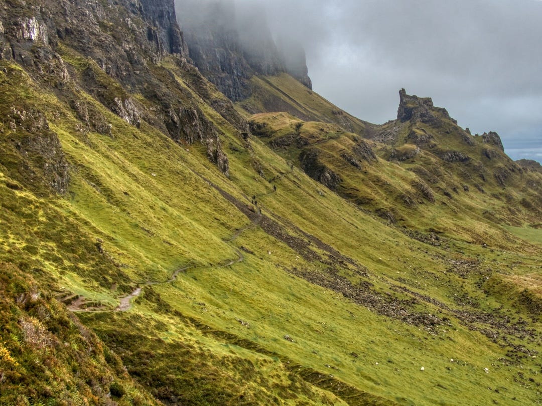
Our mid-morning arrival at the car park is met with an animated blue sky as pockets of dark clouds scuttle across from right to left. Ahead, the road twists and turns below us on its way down toward the shore. To our right, we spot several dark matchstick figures climbing the grassy escarpment leading to the plateau at Biode Buidhe. And, to our left (where we’ll be heading), a well-worn pathway leads to the first Quiraing viewpoint, just 200 metres away.
The horseshoe-shaped viewing area is not a place of solitude, however. We seem to have arrived at the same time as a bus-load of tourists hell-bent on getting perfect selfies in front of some of Scotland’s finest scenery.
To our left, we spot a series of stone steps zig-zagging their way up an escarpment. Meanwhile, in front of us, a flatter path follows the foot of the ridge until it dissects two spires in the distance. These are two of the Quiraing’s most famous rock formations – the Needle and the Prison (which we’ll return to later).
It’s one of Skye’s most iconic views. And it’s where you might choose to stop if the weather is particularly bad. Indeed, many visitors don’t go any further than this before returning to their tour bus.
The climb to the ridge
From the viewpoint, we have the option to take the lower path past the spires and then up along the ridge. But we decide to take a clockwise route by climbing up to the ridge first (via the nearby steps) and returning on the lower path. Mainly because we want to take advantage of the clearer sky before the mist and clouds roll in.
The climb up is a lung-busting one, punctuated by regular stops. Happily, they allow us to turn around and wonder at the ever-changing scenery behind us.
The scale of the Trotternish Ridge is now in full view. The gently sloping landscape to our left sweeps up from the shoreline before crashing into the sheer volcanic rock of the ridge, which now snakes away into the distance.
Meanwhile, the twin lochs of Cleat and Leum nu Luirginn resemble footprints in the boggy marshland left behind by some imaginary giant.
As our first experience of walking in Skye, it’s an exhilarating moment. And one that spurs us on to complete our climb as the steps finally give way to a marked path.

The path leads steadily upwards and past small herds of grazing sheep. The views out to sea improve with every metre, culminating in the blue expanse of Hebridean water known as The Minch ending abruptly as the craggy, snow-covered mountains of the Scottish mainland paint the sky.
Given our experience in Skye this far, we’d decided to wear Wellington boots for this hike. After all, the combination of boggy trails and very wet weather is not one to take lightly. And, as it turns out, the next section is a bog-lover’s paradise.
We reach a gate where the well-trodden path ends and the bog-fest begins. Four young American hikers on their way down, resplendent in their knee-high boggy mud, compliment us on our choice of footwear. We try to hide our smugness and assess how we’ll tackle the route ahead. We can see the top of the ridge. And all that stands between it and us is open moorland scarred by the muddy trails of sheep and hikers who’ve gone before.
In the end, we simply wing it and trust our boots to withstand the squelching, muddy bog. And it’s a bit of a slog for 15 minutes or so. But then we arrive at the summit, where the drier, firmer ground feels like a huge welcome mat.

The Quiraing
We find ourselves standing at the edge of the ridge overlooking a sheer drop to a flat, grassy area surrounded by a mighty wall of rock towers and pinnacles. Almost immediately, the unmistakeable onset of mild vertigo takes hold as the increasing wind threatens to take us for a much closer look.
We’ve arrived at the Quiraing (from the Norse Kví Rand – meaning “round fold or pen”), a craterous area which is only viewable to most people from this vantage point (it’s possible to walk up to it from the lower path but the route consists of very steep shingle and can be dangerous).
The grassy plateau is known as The Table, which (according to legend) was often used by local people hundreds of years ago to hide cattle from would-be raiders. It’s a unique, almost alien landscape befitting of a Tolkien novel. And one that we agree is worth spending some time to explore.
We continue along the edge of the ridge as the angle of the rock formations changes, revealing hidden layers. Then across steep gulleys and onto rocky ledges for photographs of the Quiraing from as many viewpoints as possible. All the while we keep our hopes up we might spot a marauding dinosaur or a mighty dragon swooping amongst the rock towers.
Alas, no such luck. Although it hasn’t stopped film-makers using the surreal location as a backdrop in movies such as The BFG, King Arthur: Legend Of The Sword, Macbeth and Stardust.


HAVE YOU CONSIDERED HOUSE SITTING?
Over the years we've saved thousands of pounds on accommodation costs by house sitting all over the world. If you’re new to the concept but want to give it a try, you’ll need to sign up for one or more specialist websites that connect homeowners with potential house sitters.
The world’s largest platform is Trusted Housesitters, with tens of thousands of opportunities around the globe. By creating a free account with them you can preview what housesits are currently on offer, filtered by country, region or city. You can do that by following this link and choosing the “Find a house sit” tab.
If you then decide to join as a member, you’ll also receive a 25% discount on your first year’s subscription Everything You Need To Know About House & Pet Sitting
Completing the circuit
Continuing past the Quiraing, the scenery completely changes as the northernmost cliffs of the Trotternish Ridge come into view, along with the coastline of northern Skye and the islands of Lewis and Harris beyond. It’s one of the reasons why we reckon it’s better to take this clockwise route of the Quiraing circuit rather than the other way round.
The footpath leads very close to the edge of the ridge with sheer drops to the lower path below. Understandably, we heed the warnings about continuing erosion and tackle the section with care.


A wooden stile marks the trail’s halfway point where the upper path meets its lower altitude partner and the route back to the car park.
After being exposed to the elements until now, we find ourselves sheltered by the sheer cliffs of the ridge to our right. But the trail becomes extremely muddy again, requiring us to venture “off-piste” more than once.

The scenery here is less interesting than that we’ve seen so far as the trail continues along the foot of the ridge. Above us, swirls of mist gather around the ridge’s summit. And ahead, the bright red of a hiker’s jacket is the only splash of contrast against a wall of green vegetation and black basalt rock.
We eventually reach a shingle section with a steep drop to two of the Quiraing’s other iconic rock formations.
To our left, The Prison, with its three summits, is said to resemble the shape of a fortress. And, to our right, the 37-metre pinnacle known as The Needle stands alone like a giant, celestial knife plunged into the earth.
We can make out an extremely steep footpath amongst the scree that heads beyond The Needle (and up to the area around The Table). It looks precarious. And judging by the looseness of the shingle on the main footpath, it probably is.
Instead, we continue beyond The Prison as the scenery opens out once more, showcasing the twin lochs of Cleat and Leum nu Luirginn and the dramatic ridge of Biode Buidhe in front of us.

Final thoughts on the Isle Of Skye Quiraing Walk
The circuit takes between two and three hours to complete, depending on the weather, your fitness level and how much you want to linger en route.
The first stepped section up to the ridge is tough going for 20-30 minutes. If that feels like too much, then we’d suggest taking the lower path as far as The Prison and returning the same way.
If the weather is poor or changeable (which is pretty likely), you might also consider taking the shorter, easier route. And be prepared to abandon your hike if the weather suddenly deteriorates!
However, if you’ve completed the trail and are ready for something more, consider crossing to the other side of the car park and following the steep path to Biode Buidhe. Along the way, there are more lochs, clifftop views and staggering rock formations to keep you entertained.
Best of all, though, the views back to the Quiraing highlight the sheer majesty of what is surely one of Scotland’s most beautiful landscapes.
PLAN YOUR OWN SELF-GUIDED CITY WALKS
We’ve teamed up with GPSmyCity to produce our very own self-guided travel articles via a FREE app on your mobile device. Which means you can download them to use as an offline travel resource for your trip. However, you can upgrade (with an annual subscription) to a GPS-enabled version of the article, which includes walking directions from your current location to any of the places featured.
And that’s in addition to the thousands of other articles from over 1,000 cities that are available for download from the GPSmyCity app.
Read our GPSMyCity app article
FAQs
How to pronounce Quiraing
The Quiraing is pronounced “kuh-RAYNG”
How do I get from Portree to The Quiraing?
The easiest way to get there is by car – follow the main road toward Staffin and then take a left turn just after Staffin (signposted “The Quiraing”) up to the car park.
The #57 bus travels from Portree to the car park at Flodigarry, from where a trail will take you up The Quiraing circuit.
You can also get there on an organised tour or with your own guide.
How long is the Quiraing walk?
The circuit is 6.8 km (4.2 miles) long and takes between two to three hours to complete, depending on your fitness levels and desire to keep moving. And, of course, the weather!
If you prefer, you can also read this post on our website.